
Why Sign Recognition Matters More Than You Think
Most drivers pass hundreds of signs on any given trip. The ones you recognize and process in a fraction of a second are the ones that keep you legal and safe. The ones you misread - or miss entirely - are where trouble starts.
The Federal Highway Administration organizes signs into three functional categories: regulatory, warning, and guide. Each has a standardized shape and color system defined in the Manual on Uniform Traffic Control Devices (MUTCD), the national standard that all US states are required to follow. Understanding that system is the real foundation of sign literacy.
| Sign system standard | Manual on Uniform Traffic Control Devices (MUTCD) (Federal Highway Administration) |
| Regulatory sign color | White with black or red text |
| Warning sign shape & color | Diamond; yellow or fluorescent yellow-green |
| School zone sign shape | Pentagon (five-sided) (Unique identifier for school-related signs) |
| Guide sign colors | Green (directions), Blue (services), Brown (recreation) |
| Solid double yellow line | No passing permitted in either direction |
If you're working with a new driver, see our guide to what new drivers need beyond the test for a broader look at real-world driving skills.
Regulatory Signs: These Are the Rules
Regulatory signs tell you what you must or must not do. Ignoring them can mean a moving violation - or worse. They are predominantly white with black or red text, and most are rectangular.
MUTCD
The Manual on Uniform Traffic Control Devices, the federal standard that defines sign shapes, colors, and meanings across all US roads. All states must substantially conform to it.
Regulatory Sign
A sign that communicates a legal requirement or prohibition. Failing to comply can result in a traffic violation. Most are white with black or red markings.
Warning Sign
A yellow diamond-shaped sign that alerts drivers to a road condition, hazard, or geometry change ahead. They inform rather than mandate, but ignoring them is risky.
Advisory Speed
A recommended speed (not a legal limit) posted beneath certain warning signs - particularly curve signs - based on engineering assessment of safe travel through that section.
HOV Lane
High-Occupancy Vehicle lane. Restricted to vehicles with a minimum number of occupants (typically two or three) during designated hours to reduce congestion.
Pavement Markings
Lines, symbols, and words painted or inlaid on the road surface that convey lane boundaries, passing rules, and turn restrictions. They carry legal force similar to signs.
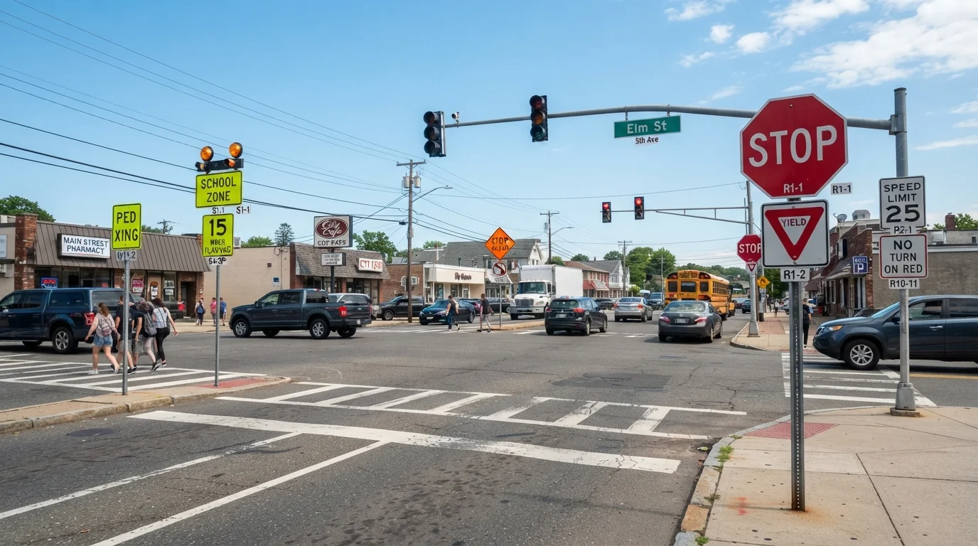
- Stop (octagon, red): Come to a complete stop before the line. You must yield to all cross traffic and pedestrians before proceeding.
- Yield (downward triangle, red/white): Slow down and give the right-of-way; stop only if necessary.
- Speed Limit (white rectangle): The maximum legal speed under ideal conditions. Speed limits drop in school and work zones - often with doubled fines.
- No Turn on Red (white rectangle, red text): You may not turn right (or left, where posted) on a red signal, even after stopping.
- Do Not Enter / Wrong Way (red): You are facing oncoming traffic. Stop immediately and reverse course. These two signs often appear together on divided highway ramps.
- One Way (black/white arrow): Traffic moves in a single direction only. Turning against it is a serious hazard.
Also watch for HOV lane signs, which restrict certain lanes to vehicles carrying two or more occupants during specified hours. Violating HOV rules typically carries a fine.
Warning Signs: Something Ahead Requires Your Attention
Warning signs are yellow (or fluorescent yellow-green) diamonds. They alert you to road conditions, geometry changes, or hazards ahead - not rules. The appropriate response is nearly always to reduce speed and increase attention.
Advisory Speed Plaques Are Not Speed Limits
When a warning sign for a curve includes a yellow speed plaque beneath it - say, "25 MPH" - that number is an engineering recommendation, not the posted speed limit. That said, it reflects careful study of the road geometry and is worth heeding. Exceeding it, especially in wet or icy conditions, significantly increases the risk of a skid or rollover.
- Curve / Winding Road: The road changes direction ahead. Advisory speed plaques beneath these signs (e.g., "35 MPH") indicate the recommended safe speed through the curve - not the legal limit, but a strong engineering-based guidance.
- Pedestrian Crossing: A crosswalk is ahead. Slow down and be prepared to stop.
- School Zone Ahead (pentagon shape, fluorescent yellow-green): The five-sided shape is unique to school-related signs. Reduced speed limits are typically in effect during school hours.
- Merge / Lane Ends: Two lanes of traffic are combining. The merging driver must yield, but courtesy and cooperative merging prevent backups.
- Railroad Crossing (X-shaped, yellow): Tracks cross the road ahead. Slow down and be prepared to stop if a train is approaching.
- Slippery When Wet: The road surface loses traction in rain. Lower your speed before the surface becomes wet - not after.
Good sign awareness pairs directly with good visibility habits. Our night driving risk-reduction guide covers how reduced visibility changes your response time to warning signs.
Guide Signs and Pavement Markings: Context and Direction
Guide signs are green, blue, or brown rectangles that provide directional, distance, and service information. They don't impose legal obligations, but misreading them can put you in the wrong lane or send you miles off route.
- Green: Destinations, route numbers, distances, and highway exits.
- Blue: Services - fuel, food, lodging, hospitals - typically seen near exits.
- Brown: Recreational areas, parks, and cultural landmarks.
Pavement markings work alongside signs and carry their own legal weight. A solid white line means you should not cross. A dashed white line permits lane changes when safe. Yellow lines separate opposing traffic; a solid double yellow means no passing in either direction.
Staying aware of all three sign categories - plus pavement markings - gives you the complete picture of what any stretch of road is communicating. Combine that with a pre-trip vehicle safety check and you're prepared before you ever encounter the first sign.